


le Plessis-Grohan _ Damville

fredtruc27
User
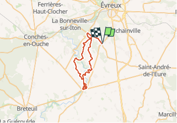

Length
42 km

Max alt
164 m

Uphill gradient
368 m
Km-Effort
47 km

Min alt
115 m

Downhill gradient
369 m
Boucle
Yes
Creation date :
2025-04-27 06:50:12.074
Updated on :
2025-04-27 09:40:39.277
2h49
Difficulty : Medium

FREE GPS app for hiking
 SityTrail
IGN / Geographical institutes
SityTrail Plus
The world is yours!
About
Trail Mountain bike of 42 km to be discovered at Normandy, Eure, Les Baux-Sainte-Croix. This trail is proposed by fredtruc27.
Positioning
Country:
France
Region :
Normandy
Department/Province :
Eure
Municipality :
Les Baux-Sainte-Croix
Location:
Unknown
Start:(Dec)
Start:(UTM)
362976 ; 5424259 (31U) N.
Comments